Tour du Mont Blanc with Sandy
DISCLAIMER: Any and all information presented in this post is the opinion of the author who is not certified in any way or an expert on any subject presented. Hiking is inherently dangerous and doing so without adequate preparation and knowledge could result in serious injury or death. This post is not intended to be comprehensive and is provided with no warranties, guarantees or representations whatsoever. Use of this information is solely at your own risk.
Table of Contents
- Introduction
- Overview
- Contrasting the TMB with the TJR
- Photo Gallery
- Overview Maps
- Accommodations
- Costs
- Packing
- Maps and Navigation
- Distances and Times
- Getting To and From the Region
- Other Fun Stuff
- Agencies/”Self Guided”
- Other Websites
- Lessons Learned and Re-learned
The following topics are covered in my post about the Switzerland hike I took with my daughter, Jen in September 2015, but the information is equally applicable to the TMB:
Introduction [TOC]
In early September 2014, Sandy and I set out to hike the Tour du Mont Blanc (the TMB), a 105 mile trek around the highest mountain in Europe, the Mont Blanc and it neighboring peaks. About three weeks prior to our departure, neither of us had ever even heard of the TMB until our friends, Julie and Jeff, mentioned it while floating in the cove. This is the first time I had been on an overnight hiking trip outside of the USA and the first time Sandy had every donned a backpack in her life. So, we both entered into the planning and the trip itself with a degree of anxiety about what to expect.
It turns out that we did fine in spite of an injury that almost ended our trip on the second day. We were able to improvise and make the loop, albeit we skipped some sections by bus to keep on pace. This post is intended to provide information about our experience that may prove helpful to anyone wishing to take on this trek. Most generally fit people should be able to hike the TMB and if you are amongst them, I have no doubt you will treasure the experience for the rest of your life.
Overview [TOC]
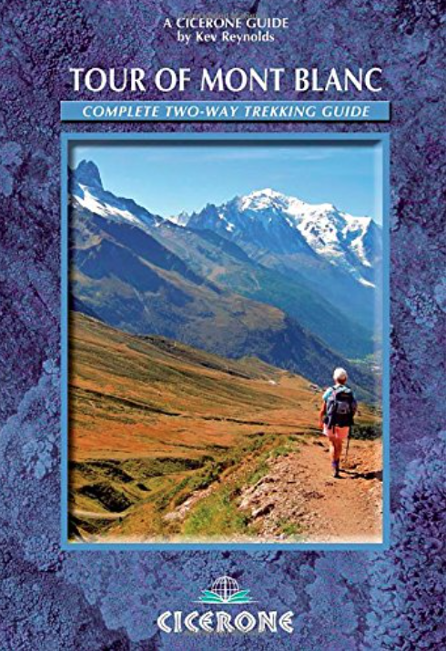
The hike is known as the Tour du Mont Blanc, or TMB for short. It is one of the most well travelled treks in Europe, in part, I believe, because of the spacing of towns and availability of refuges. The entire hike is 105 miles if you do the whole thing. We ended up doing the whole loop, but hiking only about 2/3 of it because I had an injury which slowed us down. The most well known guide book is a must have to plan and navigate the trail. Here it is:
Tour of Mont Blanc: Complete two-way trekking guide (Cicerone Guides)
Contrasting the TMB with the TJR [TOC]
I did a similar hike in 2015 with my younger daughter, Jennifer in the Jungfrau Region (the Tour of the Jungfrau Region – TJR for short). See my Switzerland post. Both hikes were spectacular and difficult to recommend one over the other. Here is how I compare the two:
Natural Beauty – Taking nothing from the TMB, I really liked the lush green valleys and sheer granite cliffs in the Jungfrau area, so on the measure of pure beauty, I would give the Jungfrau Region the edge. Again, as you can see from the photos below, the TMB is not lacking of beautiful scenes at every turn.
Accommodations – The TMB is more refined as a known hiking destination and therefore the refuges have better facilities, on balance. For example, the TMB had showers in every facility. While hiking for about the same time in the TJR, we encountered three refuges in which the “shower” was expressed in a single double-sink, to be shared amongst all guests. One was even outdoors and another had all but a trickle. Although we stayed in some great places on the TJR, TMB definitely has the edge on facilities.
People – We met wonderful people on both trips. Given that the TMB is a more well established route, more people naturally offered a better opportunity to meet interesting people. That is just a matter of numbers. When we had a designated place to sit at dinner we always had good conversation opportunities. The TMB just had more of those opportunities. So, on people meeting, I give the nod to the TMB.
Bugs – We did not have a bug problem on the TMB at all. On the TJR, flies were a nuisance. They do not bite, but often had to be fanned away in the dining rooms. So, TMB wins the battle of the bugs.
Photo Gallery [TOC]
Here are the photos from our trip, more or less in order (note: You have to go in the “previous” direction, not “next” until if fix this on the site)….
Overview Maps [TOC]
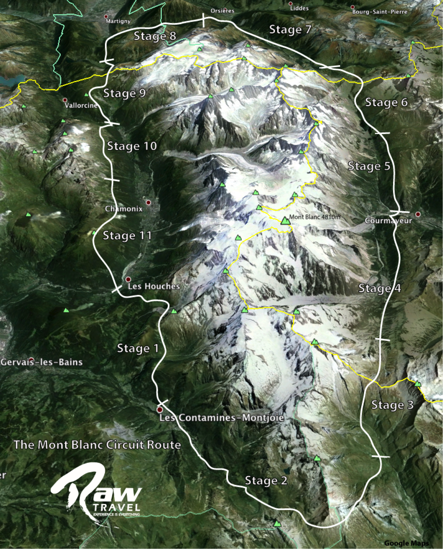
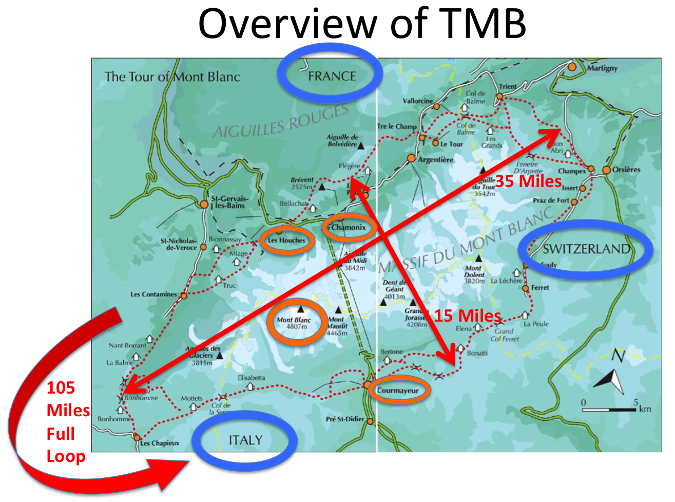
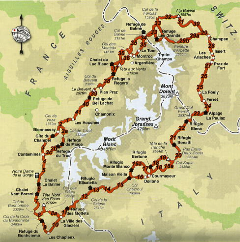
The trail can be hiked in either direction and from any point. Most people start in Les Houches and hike counterclockwise. So you start in France, hike to Italy, then Switzerland, then back to France. Total loop is 105 miles. Chamonix and Courmayeur are the two main towns on each side of the mountain, although the trail goes through several other small towns. A tunnel connects the two. We stayed in Les Houches, but really should have stayed in Charmonix. Les Houches is dead in the summer and you’ll need to take a bus to Charmonix for entertainment. Just take the bus to Les Houches to start the trip.
Below is a great overview map. You can see that the trail generally is on the opposite side of the valley surrounding the Monte Blanc mountain range, so your view is generally of the range. So, most days you hike up through a pass and back down to the next town or refuge. It shows how the hike proceeds in 11 “stages,” which are the traditional 11 nights or so, consistent with the Guide Book mentioned above. Going that fast would be “booking it.” We were in the area for 16 days, hiking 11 of those days and covered 2/3 of the 105 miles. There are ways to do a “quick version” which takes buses here and there to cut down the milage. Where there are roads, you’ll likely find busses. So get a map and plan accordingly.
 Accommodations [TOC]
On the trip, we ran into people who had been planning the trip for two years and most had made reservations months in advance. Other than the first three nights, we had no reservations. Planning was difficult because we had really no idea how fast we could hike. It seemed pointless to plan too far ahead because surely we would be wrong about our speed. We were right.
The guidebook is divided into 11 segments, so, theoretically, you can hike the 105 miles of the TMB in 11 days. To account for the uncertainty of of our speed, we allowed 15 days for the full trip. Because of an injury, we spent time resting and took bus to cover some sections which we deemed less interesting. We completely improvised and was not a problem. We started with reservations for the first three nights and then just tried to call a couple of days ahead to secure our reservations as we progressed.
The “season” theoretically runs from June to mid-September. Because we started September 3, reservations were no problem even a day prior to arrival; however, a few places were closed on the tail end, including the cable car down to Les Houches. So we had to adjust a little on the tail end. Here are the locations we stayed and the nights we stayed there.
- [1] Le Houches – Hotel
- [2] Miage – Highly recommended. 80% full
- [3] Borrant – 100% full
- [4] Bohomme – 80% full
- [5] Mottes – 90% full
- [6] Elesabeta – 80% full
- [7, 8] Courmayer – Hotel
- [9] La Foley – 80% full
- [10] Trient – 70% full
- [11,12,13,14] Argentere – Hotel
Here is link to a pdf file for the accommodations in order around the trail: TMB Accomodations-With Areas. Here is the link to a site where you can book most refuges direct from one site: Refuges autour du Mont-Blanc – réservez en ligne votre tour du Mont-Blanc. There is also a companion iPhone app which is good on the trail. The following map shows most of the major refuges (does not show some where we stayed or hotels in major towns):
Costs [TOC]
Costs can vary, depending on if you sleep in dorm or private rooms. We opted for private rooms where available (all but 3 nights we had private room; other nights we shared with 2-4 other people). For the 16 days we were in the TMB area, we spent a total of $6,000. Completely self-guided with no agency and never a problem with accommodations. That included a few nice dinners when in the major towns, lift tickets from both Charmonix and Courmeyeur sides to see the top of the mountain, bus tickets and all food/accommodations. We used miles for airfare to/from Geneva, Switzerland, so that would be extra, probably $3,000 for both of us.
Here is a full list of all of the accommodations along the route (again, major towns, additional lodging options are available, but be sure to check how far to walk in the town): TMB Accomodations-With Areas
Packing [TOC]
No need to bring sleeping bag, tent or cooking utensils. Do carry a lightweight silk sleeping wrap. Some people arrange baggage transfers from point to point so that they don’t have to carry as much on the trail. We did not do that. My pack weighed about 22 pounds without water and Sandy’s pack weighed about 15 without water. In most areas, you don’t need to carry drinking water. We used a Gatorade bottle and blue ‘life straw” which significantly cut down on the weight of water to carry each day. Click here to see my post on Switzerland; packing list on that post. Here is a link to a different sit with a good list: Mont Blanc Treks : Trekking kit list.
Maps and Navigation [TOC]
I would HIGHLY, HIGHLY, HIGHLY recommend obtaining the Switzerland Mobility application and plotting your course in advance (cost $30 annually and well worth the price). I describe it in detail in my post for the 2015 trip with my daughter, Jen. Sandy and I did not know about this app for the TMB, but it definitely covers the region. We managed, but it would have been much easier and navigation less stressful if we had the app. As it stood, I used paper maps and the guidebook to navigate. The TMB is a well marked trail and it is designated as the TMB on every segment of the trip. Regardless, having an app which shows the detailed trails and also a dot with our location would have been immensely valuable.
These are the maps I purchased while in Chamonix and I recommend as a backup to the app. You can run out of battery and it could be a problem.
Times and Distances [TOC]
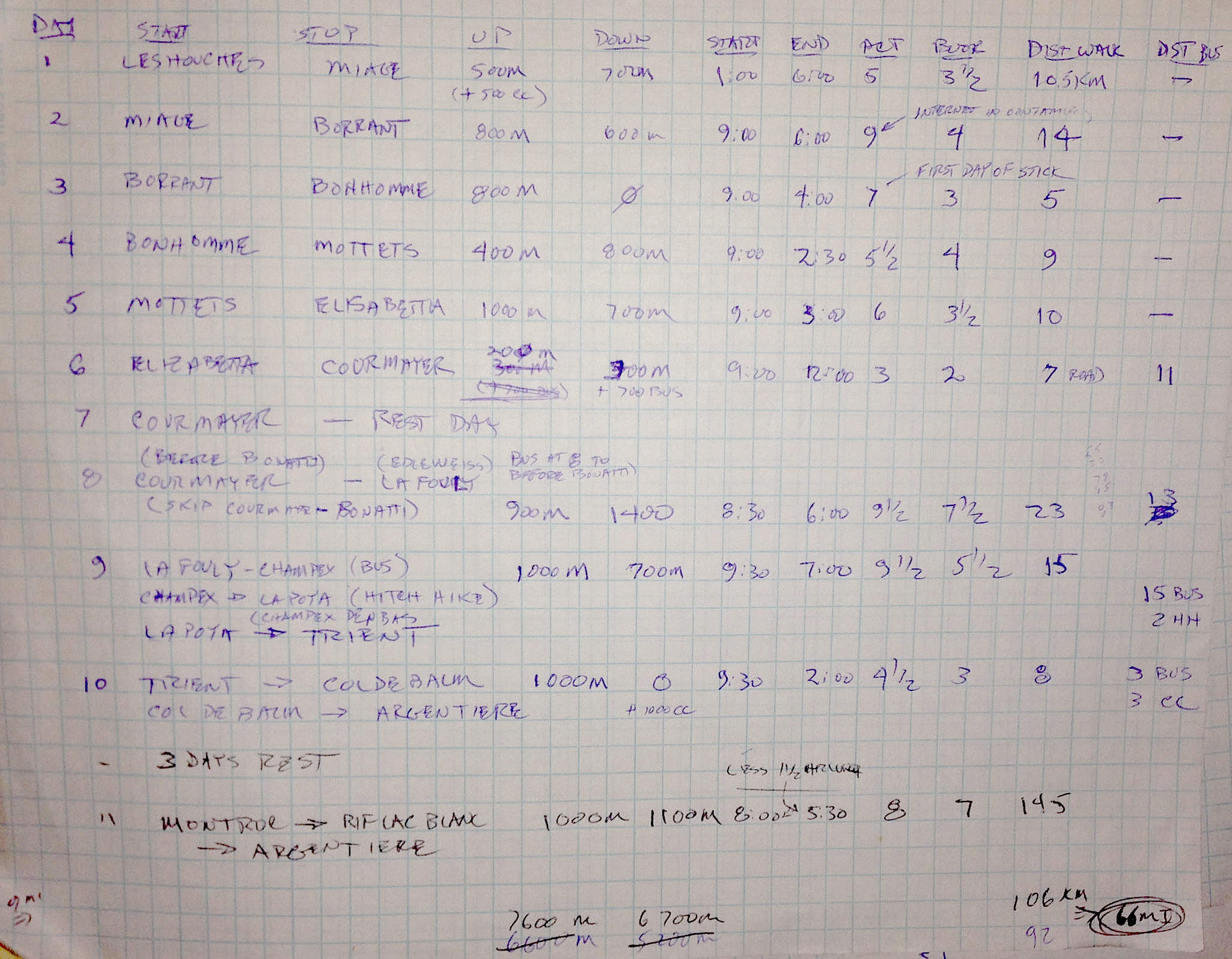
Here is a spreadsheet of the “guide book” times and distances. Keep in mind that the times are without breaks and moving along at nice clip. With fit kids, I would plan on 1.5X what is listed.
TMB Times and Distances per Guidebook – Download PDF
Here are the actual times vs the guidebook. You can see that in the latter part of the trip we were more fit, covering longer distances and closer to guidebook numbers. BTW, the guidebook numbers do not include breaks of any sort. So, expect to be slower than guidebook regardless unless you are a speedster.
Getting to and from Charmonix [TOC]
Buy a plane ticket to Geneva, however you can best get there. We flew through Amsterdam. Once there, the bus was very good option at 135 CHF for two people, round trip. Easy to buy a bus ticket at the airport when you arrive in Geneva. Stay overnight in Charmonix unless you are starting your hike same day. When ready to start, take bus to Les Houches. We took cable car up to top from Les Houches to take the bite out of the first day. Glad we did.
Other Fun Stuff [TOC]
A link to fun things to do on the trek. The hub is Chamonix for most fun, but Courmayeur is also good option. We REALLY wanted to do the parasailing, but weather did not cooperate. Canyoning is also VERY fun and I think could be OK for kids.
Rhone-Alpes Adventure – 192 Rhone-Alpes Adventure Attractions – TripAdvisor
Agencies/”Self Guided” [TOC]
See the analysis in my Switzerland post in the “Cost” section.
Other Web Sites [TOC]
The following are very good overview sites, mostly by individual hikers:
The Tour du Mont Blanc: A guide to the trek, by Alpine Exploratory
My thru-hike of the Tour du Mont Blanc | DZJOW’S ADVENTURE LOG
Tour Mont Blanc, walking, France, Europe, Switzerland, Italy, hiking trail
Mont Blanc Image Gallery – Mont Blanc TreksMont Blanc TreksLessons Learned and Relearned [TOC]
- See lessons learned in my Switzerland post. They are the same for this region, except not as many flies. In fact, not many at all.

Jack,
Thanks for the wonderful guidance. Will be trekking around Mont Blanc in June. Your blog is a great inspiration, as well as very encouraging re fitness, and the likelihood I will be able to accomplish the planned tour. Your pictures also provide great incentive.
Thanks David. I’m glad it helped. Let me know how the trip goes!